En-route Control Center definitions
If you want more room Captain, push your seat back.
- ORD ATC.
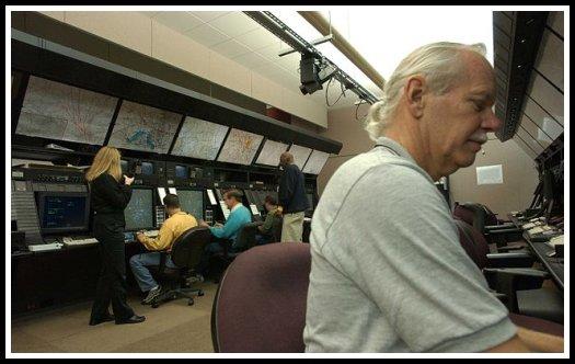
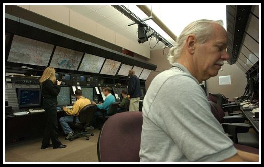
Air route traffic controllers at work at the Washington ARTCC
Area Control Center
In air traffic control, an Area Control Center (ACC), also known as a Center, is a facility responsible for controlling aircraft en route in a particular volume of airspace (a Flight Information Region) at high altitudes between airport approaches and departures. In the United States, such a Center is referred to as an Air Route Traffic Control Center (ARTCC).
A Center typically accepts traffic from, and ultimately passes traffic to, the control of a Terminal Control Center or of another Center. Most Centers are operated by the national governments of the countries in which they are located. The general operations of Centers worldwide, and the boundaries of the airspace each Center controls, are governed by the ICAO.
In some cases, the function of an Area Control Center and a Terminal Control Center are combined in a single facility. For example, NATS combines the London Terminal Control Centre (LTCC) and London Area Control Centre (LACC) in Swanwick in the UK.
The United States Federal Aviation Administration defines an ARTCC as a facility established to provide air traffic control service to aircraft operating on IFR flight plans within controlled airspace, principally during the en route phase of flight. When equipment capabilities and controller workload permit, certain advisory/assistance services may be provided to VFR aircraft. An ARTCC is the U.S. equivalent of an Area Control Center (ACC).
The Flight Information Region controlled by a Center may be further administratively subdivided into Areas comprising two to seven sectors. Each Area is staffed by a set of controllers trained on all the sectors in that area. Sectors use a distinct radio frequencies for communication with aircraft. Each sector also has secure landline communications with adjacent sectors, approach controls, areas, ARTCCs, flight service centers, and military aviation control facilities. These landline communications are shared among all sectors who need them and are available on a first-come, first-serve basis. Aircraft passing from one sector to another shall be handed off and requested to change frequencies to contact the next sector controller. Sector boundaries are specified by an aeronautical chart.
Air traffic controllers working within a Center communicate via radio with pilots of instrument flight rules aircraft passing through the Center's airspace. A Center's communication frequencies (typically in the very high frequency amplitude modulation aviation bands, 118 MHz to 137 MHz, for overland control) are published in aeronautical charts and manuals, and will also be announced to a pilot by the previous controller during a hand-off. In addition to radios to communicate with aircraft, Center controllers have access to communication links with other Centers and TRACONs. In the United States, Centers are electronically linked through the National Airspace System, which allows nationwide coordination of traffic flow to manage congestion. Centers in the United States also have electronic access to nationwide radar data.
Controllers use radar to monitor the progress of flights and instruct aircraft to perform course adjustments as needed to maintain separation from other aircraft. Aircraft with Center contact can be readily distinguished by their transponders. Pilots may request altitude adjustments or course changes for reasons including avoidance of turbulence or adverse weather conditions. Controllers can assign routing relative to location fixes derived from latitude and longitude, or from radionavigation beacons such as VORs. Typically, Centers have advance notice of a plane's arrival and intentions from its pre-filed flight plan.
Some Centers have ICAO-designated responsibility for airspace located over an ocean such as ZOA, the majority of which is international airspace. Because substantial volumes of oceanic airspace lie beyond the range of ground-based radars, oceanic airspace controllers have to estimate the position of an airplane from pilot reports and computer models (procedural control), rather than observing the position directly (radar control, also known as positive control). Pilots flying over an ocean can determine their own positions accurately using the Global Positioning System and can supply periodic updates to a Center. A Center's control service for an oceanic FIR may be operationally distinct from its service for a domestic overland FIR over land, employing different communications frequencies, controllers, and a different ICAO code. Pilots typically use high frequency radio instead of very high frequency radio to communicate with a Center when flying over the ocean, because of HF's relatively greater propagation over long distances.
General characteristics
En-route air traffic controllers work in facilities called Area Control Centers, each of which is commonly referred to as a "Center". The United States uses the equivalent term Air Route Traffic Control Center (ARTCC). Each center is responsible for many thousands of square miles of airspace (known as a Flight Information Region) and for the airports within that airspace. Centers control IFR aircraft from the time they depart from an airport or terminal area's airspace to the time they arrive at another airport or terminal area's airspace. Centers may also "pick up" VFR aircraft that are already airborne and integrate them into the IFR system. These aircraft must, however, remain VFR until the Center provides a clearance.
Center controllers are responsible for climbing the aircraft to their requested altitude while, at the same time, ensuring that the aircraft is properly separated from all other aircraft in the immediate area. Additionally, the aircraft must be placed in a flow consistent with the aircraft's route of flight. This effort is complicated by crossing traffic, severe weather, special missions that require large airspace allocations, and traffic density. When the aircraft approaches its destination, the center is responsible for meeting altitude restrictions by specific points, as well as providing many destination airports with a traffic flow, which prohibits all of the arrivals being "bunched together". These "flow restrictions" often begin in the middle of the route, as controllers will position aircraft landing in the same destination so that when the aircraft are close to their destination they are sequenced.
As an aircraft reaches the boundary of a Center's control area it is "handed off" or "handed over" to the next Area Control Center. In some cases this "hand-off" process involves a transfer of identification and details between controllers so that air traffic control services can be provided in a seamless manner. In other cases local agreements may allow "silent handovers" such that the receiving center does not require any co-ordination if traffic is presented in an agreed manner. After the hand-off, the aircraft is given a frequency change and begins talking to the next controller. This process continues until the aircraft is handed off to a terminal controller ("approach").
Radar coverage
Since centers control a large airspace area, they will typically use long range radar that has the capability, at higher altitudes, to see aircraft within 200 nautical miles (370 km) of the radar antenna. They may also use TRACON radar data to control when it provides a better "picture" of the traffic or when it can fill in a portion of the area not covered by the long range radar.
In the U.S. system, at higher altitudes, over 90% of the U.S. airspace is covered by radar and often by multiple radar systems. However, coverage may be inconsistent at lower altitudes used by unpressurized aircraft due to high terrain or distance from radar facilities. A center may require numerous radar systems to cover the airspace assigned to them, and may also rely on pilot position reports from aircraft flying below the floor of radar coverage. This results in a large amount of data being available to the controller. To address this, automation systems have been designed that consolidate the radar data for the controller. This consolidation includes eliminating duplicate radar returns, ensuring the best radar for each geographical area is providing the data, and displaying the data in an effective format.
Centers also exercise control over traffic traveling over the world's ocean areas. These areas are also FIRs. Because there are no radar systems available for oceanic control, oceanic controllers provide ATC services using procedural control. These procedures use aircraft position reports, time, altitude, distance, and speed to ensure separation. Controllers record information on flight progress strips and in specially developed oceanic computer systems as aircraft report positions. This process requires that aircraft be separated by greater distances, which reduces the overall capacity for any given route.
Some Air Navigation Service Providers (e.g. Airservices Australia, The Federal Aviation Administration, NAVCANADA, etc.) have implemented Automatic Dependent Surveillance - Broadcast (ADS-B) as part of their surveillance capability. This new technology reverses the radar concept. Instead of radar "finding" a target by interrogating the transponder, the ADS-equipped aircraft sends a position report as determined by the navigation equipment on board the aircraft. Normally, ADS operates in the "contract" mode where the aircraft reports a position, automatically or initiated by the pilot, based on a predetermined time interval. It is also possible for controllers to request more frequent reports to more quickly establish aircraft position for specific reasons. However, since the cost for each report is charged by the ADS service providers to the company operating the aircraft, more frequent reports are not commonly requested except in emergency situations. ADS is significant because it can be used where it is not possible to locate the infrastructure for a radar system (e.g. over water). Computerized radar displays are now being designed to accept ADS inputs as part of the display. This technology is currently used in portions of the North Atlantic and the Pacific by a variety of states who share responsibility for the control of this airspace.
Precision approach radars are commonly used by military controllers of airforces of several countries, to assist the pilot in final phases of landing in places where Instrument Landing System and other sophisticated airborne equipment are unavailable to assist the pilots in marginal or near zero visibility conditions. This procedure is called Talkdown.
A Radar Archive System (RAS) keeps an electronic record of all radar information, preserving it for a few weeks. This information can be useful for search and rescue. When an aircraft has 'disappeared' from radar screens, a controller can review the last radar returns from the aircraft to determine its likely position. RAS is also useful to technicians who are maintaining radar systems.
Flight traffic mapping
The mapping of flights in real-time is based on the air traffic control system. In 1991, data on the location of aircraft was made available by the Federal Aviation Administration to the airline industry. The National Business Aviation Association (NBAA), the General Aviation Manufacturers Association, the Aircraft Owners and Pilots Association, the Helicopter Association International, and the National Air Transportation Association petitioned the FAA to make ASDI information available on a "need-to-know" basis. Subsequently, NBAA advocated the broad-scale dissemination of air traffic data. The Aircraft Situational Display to Industry (ASDI) system now conveys up-to-date flight information to the airline industry and the public. Some companies that distribute ASDI information are FlightExplorer, FlightView, and FlyteComm. Each company maintains a website that provides free updated information to the public on flight status. Stand-alone programs are also available for displaying the geographic location of airborne IFR (Instrument Flight Rules) air traffic anywhere in the FAA air traffic system. Positions are reported for both commercial and general aviation traffic. The programs can overlay air traffic with a wide selection of maps such as, geopolitical boundaries, air traffic control center boundaries, high altitude jet routes, satellite cloud and radar imagery.
UTC | Zulu Time
Copyright © 2012 Roger. All rights reserved. | Sitemap